Intro to Wetland Ecology and Mapping
Join Bark staff and Insitute for Natural Resources Wetland Ecologist Kyla Zaret to learn about basic wetland ecology and Barks work to update the National Wetland Inventory on Mt. Hood!
This class will be an integral first step in learning how to identify wetlands and verify wetland maps and classification codes on Mt. Hood. Wetland 201, an in-the-field event, will follow later in the summer.
Location: Bark Office, 351 NE 18th Avenue, Portland, OR 97232
Date and Time: Wednesday, 5/29. 6pm-8pm.
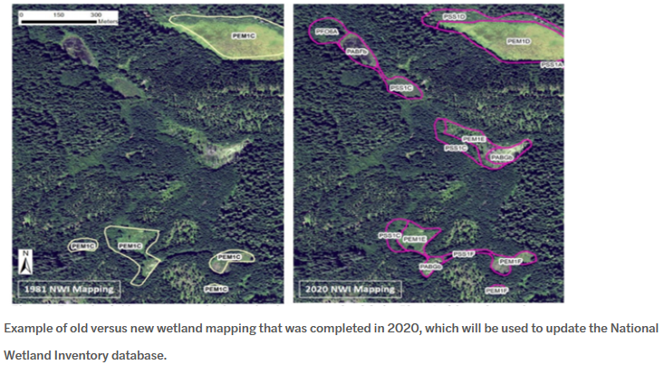
The Cowardin Classification System is used by the National Wetlands Inventory, a program of the US Fish and Wildlife Service, and it’s the standard classification system for wetland mapping across the U.S.
NWI mapping has been completed for most of the United States, however most of the mapping in Oregon occurred in the 1980s or earlier. Because these were based on low-resolution imagery, the current NWI does not represent the number, types or boundaries of wetlands as they exist now.
Our project on wetland mapping verification has the goal of updating the NWI mapping for project areas within Mt. Hood National Forest. Bark volunteers, as well as our partnership with Kyla Zaret, wetland ecologist with the Institute for Natural Resources at PSU, are integral to this multi-year program.